| Maps Here are some of the maps of the
area, descriptions of the route, base camp and the route
to the summit.
 Preliminary
route Preliminary
route
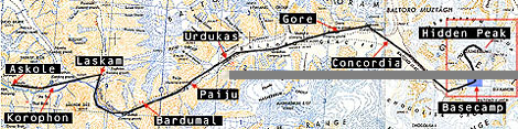
Map Askole
- Hidden peak summit
Updated 1997-07-01 07:57
| Maj 31 |
Stockholm |
Airplane |
|
| |
Copenhagen |
Airplane |
|
| |
Skardu |
Bus/Truck/Airplane |
|
| June 6 |
Askole |
Trekking |
Pakistan |
| |
Korophon |
Trekking |
Baltoro
glacier |
| |
Laskam |
Trekking |
|
| |
Bardumal |
Trekking |
|
| |
Paiju |
Trekking |
|
| |
Urdukas |
Trekking |
|
| |
Gore
2 |
Trekking |
|
| |
Concordia |
Trekking |
|
| June 20 |
Hidden Peak
Basecamp |
Acclimatization |
5 150 meters |
| |
C1 Camp |
Climbing |
5 950 meters |
| |
C2 Camp |
Climbing |
6 200 meters |
| |
C3 Camp |
Climbing |
>7 000 meters |
| |
C4 Camp |
Climbing |
apx. 7 100-7 300
meters |
| |
ev. C5 |
Climbing |
>7 400 meters |
| Juli 20 |
Hidden
Peak |
Attempt
for the top |
8 086
meters |
The route description will be continuesly
updated.
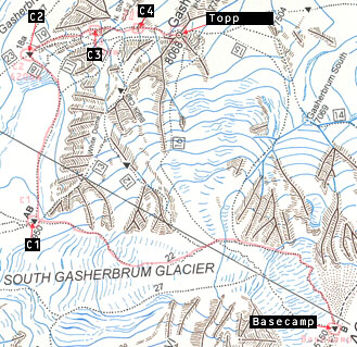
Map - Hidden Peak Basecamp and the summit

Latest News Log-book Weather Maps Description Procedure
Participants Trekking Gruope Himalaya Pakistan Hidden Peak Gallery
Equipement Sponsors Links Press Clippings Other
Contact Us Back home...
Web Design and
internet provider - Teknikhuset i Umeå, Sweden
© Copyright 1997 Svenska Hidden Peak Expeditionen 1997
All rights reserved
|