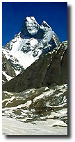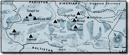
Karakoram
The name Karakoram is
Turkish and means "black rock". Originally the
name only stood for the 5671m high passage with the same
name in the mountain ranges south-eastern end. Through
this passage caravans made their way from Tibet to
Turkestan. It was a feared passage were skelettons could
be seen along the roadside the last kilometers due to
exaustion, thurst or cold weather.
Karakoram contains the
worlds largest continues ice layer besides the Arctic and
Antarctic. On the central ridge both sides the worlds
longest glacier stretch out: Siachen (73 km), Baltoro (66
km), Hispar (61 km) and Biafo (61 km).

 The
glaciers of Karakoram The
glaciers of Karakoram
 The Karakoramien
glaciers can move very fast. For example the Hasanabad
glacier during 1904 moved apx. 7 km within 2 months, an
average of 5m/hour. 1953 Kutiah glacier moved with a
speed of 113m /day. The special conditions surrounding
the glaciers that cause these incredible speeds. More ice
and snow are added to the glacier than melts away. The
added amounts come from lavines that come crashing domw
from the mountain walls which are too steep for the ice
and snow to be able to hold on. The Karakoramien
glaciers can move very fast. For example the Hasanabad
glacier during 1904 moved apx. 7 km within 2 months, an
average of 5m/hour. 1953 Kutiah glacier moved with a
speed of 113m /day. The special conditions surrounding
the glaciers that cause these incredible speeds. More ice
and snow are added to the glacier than melts away. The
added amounts come from lavines that come crashing domw
from the mountain walls which are too steep for the ice
and snow to be able to hold on.
More
on glaciers...
Latest News Log-book Weather Maps Description Procedure
Participants Trekking Gruope Himalaya Pakistan Hidden Peak Gallery
Equipement Sponsors Links Press Clippings Other
Contact Us Back home...
Web Design and
internet provider - Teknikhuset i Umeå, Sweden
© Copyright 1997 Svenska Hidden Peak Expeditionen 1997
All rights reserved
|